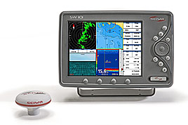

Seiwa - SW110110.4 inches multifunction chartplotter with external GPS antenna. Key features on screen (cartographical plotter, fishfinder, radar, wind data) with SVGA (800x600 pixels), sunlight viewable LCD.
Technische ficheHandleidingNiet meer verkrijgbaar
The SW1101 multifunction chartplotter (cartographical plotter, fishfinder, radar, wind data) with SVGA sunlight viewable LCD, completes the range of flush mounted instruments which can be built-in on your dash board.
The SW1101 features 2 video inputs, to control on-board areas and guarantee safety during navigation, as well as 1 video output for repeating all the information available wherever needed.
SW1101 comes with external GPS, with high resolution display 800x600 pixel SVGA. It is extremely fast responsive, completely waterproof (IP67), and can be flush mount (completely built in, on a level with the helm) or bracket mounted.
SW1101 can be transformed into a radar when connected to one of the Seiwa radar scanners.
The SW1101 features a powerful and user friendly state-of-the-art software, now updated with outstanding graphics and cutting edge functions such as free downloadable weather overlays and forecasts, 3D perspective view, HD photos, tidal heights and currents as well as the Guardian Alarm which checks your route for potential grounding issues.
If SW1101 is combined with SEIWA Black Box Fish Finder (50/200Khz, 100W), you can choose from a full screen sounder display or split screen sounder/chart plotter, and can be coupled with various kinds of plastic stern thru hull transducers, or in hull transducers, or bronze thru hull transducers: the unit works with Xid AIRMAR transducers.
Soft Keys are available to guarantee maximum efficiency and easiness of use, which change function depending upon the current display with an easy key label prompted on the screen.
SW1101 Series is compatible with DSC and AIS equipments and is equiped with WAAS/EGNOS/MSAS GPS active antenna.
The units are compatible with C-MAP by Jeppesen cartography, using SD cartridges.